Property Record
930 New Hope Rd, Lawrenceville, GA 30045
NEARBY LISTINGS FOR SALE OR LEASE
Property Detail
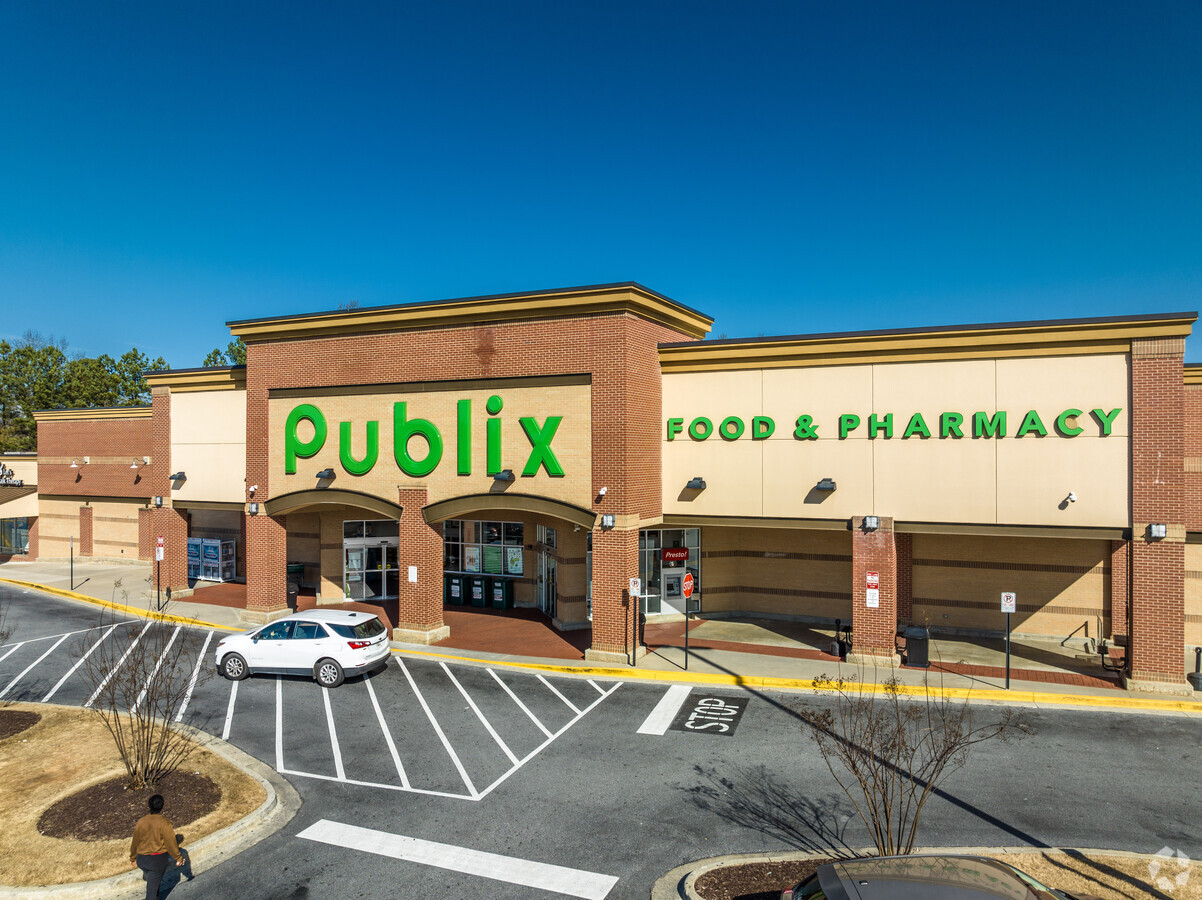
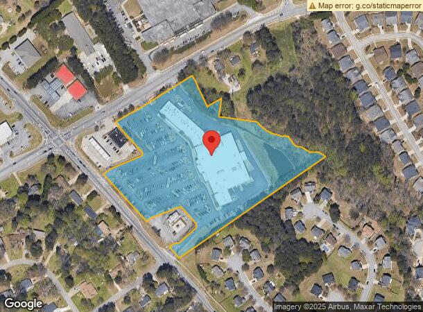
930 New Hope Rd
Atlanta-Sandy Springs-Roswell, GA
Village Shops At Simonton
5-171-476
L2 BA VILLAGE SHOPS AT SIMONTON
Regionalshoppingcenterormallwithanchorstore
Gwinnett
X
Georgia
13135C0090F
2
2023
9.48 AC
2023
Lawrenceville/Dacula
050586
Atlanta
68,134 SF
DEMOGRAPHICS near 930 New Hope Rd
1 Mile
3 Mile
5 Mile
2024 Total Population
9,467
72,852
161,324
2029 Population
9,888
76,000
168,791
Pop Growth 2024-2029
+ 4.45%
+ 4.32%
+ 4.63%
Average Age
37
36
37
2024 Total Households
2,823
22,485
50,600
HH Growth 2024-2029
+ 4.53%
+ 4.43%
+ 4.73%
Median Household Inc
$86,100
$77,278
$81,240
Avg Household Size
3.20
3.10
3.10
2024 Avg HH Vehicles
2.00
2.00
2.00
Median Home Value
$275,846
$298,251
$308,780
Median Year Built
1999
2000
1999
Nearby Places
- Restaurants
- Banks
- Shops
- Fitness
- Groceries
SALE & LEASE HISTORY
LISTING DATE
SALE/LEASE

May 12, 2017
For Lease
Jun 07, 2017
For Lease
Feb 24, 2021
For Lease
Dec 15, 2016
For Lease
Aug 24, 2017
For Lease
Aug 16, 2017
For Lease
Nearby Properties
Address
Land Use
TOTAL SIZE
Lot Size
Zoning
Address
Land Use
TOTAL SIZE
Lot Size
Zoning
29,294 SF
24.24 AC
LM
Address
Land Use
TOTAL SIZE
Lot Size
Zoning
1,103,220 SF
66.65 AC
OI
Address
Land Use
TOTAL SIZE
Lot Size
Zoning
493,072 SF
12.67 AC
BG
Address
Land Use
TOTAL SIZE
Lot Size
Zoning
16,062 SF
89.78 AC
BG
Address
Land Use
TOTAL SIZE
Lot Size
Zoning
484,422 SF
34.27 AC
RM
Address
Land Use
TOTAL SIZE
Lot Size
Zoning
352,924 SF
86.43 AC
R100
Address
Land Use
TOTAL SIZE
Lot Size
Zoning
188,749 SF
103.66 AC
RA200
Address
Land Use
TOTAL SIZE
Lot Size
Zoning
321,476 SF
38.63 AC
RMM
Address
Land Use
TOTAL SIZE
Lot Size
Zoning
13.16 AC
AA010
Address
Land Use
TOTAL SIZE
Lot Size
Zoning
333,734 SF
24 AC
BG
Address
Land Use
TOTAL SIZE
Lot Size
Zoning
221,082 SF
12.90 AC
RM24
Address
Land Use
TOTAL SIZE
Lot Size
Zoning
110,564 SF
7.76 AC
RM8
Address
Land Use
TOTAL SIZE
Lot Size
Zoning
812,946 SF
82.22 AC
BG
Address
Land Use
TOTAL SIZE
Lot Size
Zoning
262,396 SF
4.57 AC
OI
Address
Land Use
TOTAL SIZE
Lot Size
Zoning
126,160 SF
15.15 AC
BG
Address
Land Use
TOTAL SIZE
Lot Size
Zoning
175,190 SF
11.17 AC
RM
Address
Land Use
TOTAL SIZE
Lot Size
Zoning
289,004 SF
17.39 AC
OI
Address
Land Use
TOTAL SIZE
Lot Size
Zoning
59,949 SF
71.12 AC
C1
Address
Land Use
TOTAL SIZE
Lot Size
Zoning
132,916 SF
10.23 AC
BG
Address
Land Use
TOTAL SIZE
Lot Size
Zoning
240,509 SF
19.18 AC
RM
Address
Land Use
TOTAL SIZE
Lot Size
Zoning
176,034 SF
92.85 AC
RA200
Address
Land Use
TOTAL SIZE
Lot Size
Zoning
229,868 SF
17.46 AC
RM
Address
Land Use
TOTAL SIZE
Lot Size
Zoning
101,193 SF
5.34 AC
C2
Address
Land Use
TOTAL SIZE
Lot Size
Zoning
145,681 SF
49.84 AC
RA200
Address
Land Use
TOTAL SIZE
Lot Size
Zoning
101,816 SF
16.38 AC
OI
Address
Land Use
TOTAL SIZE
Lot Size
Zoning
164,957 SF
11.55 AC
RM
Address
Land Use
TOTAL SIZE
Lot Size
Zoning
571,230 SF
64.70 AC
LM
Address
Land Use
TOTAL SIZE
Lot Size
Zoning
120,847 SF
8.71 AC
BG-GENERAL
Address
Land Use
TOTAL SIZE
Lot Size
Zoning
66,261 SF
16.90 AC
BG-GENERAL
Address
Land Use
TOTAL SIZE
Lot Size
Zoning
45,826 SF
1.25 AC
BGC-CENTRA
The World's #1 Commercial Real Estate Marketplace
Connect with us
© 2025 CoStar Group
The information above has been obtained from sources believed reliable. While we do not doubt its accuracy we have not verified it and make no guarantee, warranty or representation about it. It is your responsibility to independently confirm its accuracy and completeness. Any projections, opinions, assumptions, or estimates used are for example only and do not represent the current or future performance of the property. The value of this transaction to you depends on tax and other factors which should be evaluated by your tax, financial, and legal advisors. You and your advisors should conduct a careful, independent investigation of the property to determine to your satisfaction the suitability of the property for your needs.